threatened

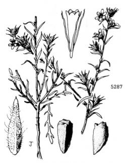
Illustration from Ferris (1960).

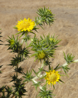
Photo taken in Livermore, Alameda County © 2011 Neal Kramer.

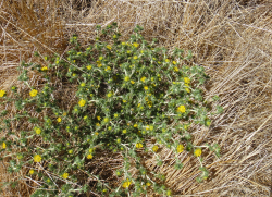
Photo © 2011 Neal Kramer.


This fact sheet was prepared by Dylan M. Neubauer under award NA04N0S4200074 from the National Oceanic and Atmospheric Administration (NOAA), U.S. Department of Commerce (DOC). The statements, findings, conclusions, and recommendations are those of the authors and do not necessarily reflect the views of the NOAA or the DOC.
© Copyright 2006, Elkhorn Slough Coastal Training Program
Last updated: Jun 2, 2015 15:17
Common Names - Congdon's tarplant
Family - Asteraceae (Sunflower Family)
State Status - none
Federal Status - none
Habitat
Seasonal wetlands on heavy clay, saline, or alkaline soils in grasslands and disturbed sites; typically growing in colonies, most common in areas that retain water for a longer period of time and in areas that have a lower density of competing non-native annual grasses. Historical locations in the Salinas Valley probably occurred on less-saline soils than elsewhere; < 300 m.
Key Characteristics
Annual herb to 7 dm tall, stems erect to spreading; forming basal rosette of leaves early in season, early cauline leaves linear, toothed at tip, both basal and cauline leaves generally senescent at flowering, with spiny secondary leaves appearing as the plants bolt; leaves and peduncle bracts seldom glandular, occasionally with minute, stalked yellowish glands among non-glandular hairs; rays yellow, generally 2.5–3 mm, disk pappus present (absent in similar-appearing C. pungens ssp. pungens), anthers yellow or brownish (Baldwin 2013). With its spiny habit, this plant is very similar to and can be confused with the very common weedy tarplant (C. pungens ssp. pungens).
Flowering Period
May to November
Reference Population
Fort Ord National Monument (Monterey County)
Global Distribution
Endemic to Central California, in San Luis Obispo, Monterey, Santa Clara, Santa Cruz, San Mateo, Alameda, Contra Costa, and Solano (presumably extirpated) counties (CNPS 2013).
Conservation
This taxon is a member of the tarweed tribe, a diverse group with many endemics in both California and Hawaii. Many California species are weedy, and an equal number are very rare.
The 1909 College Lake collection near Watsonville in Santa Cruz County is presumed extirpated. However, a small population was relocated in the Watsonville Wetlands in 2008. Much of the former habitat for this plant was lost to early agricultural conversion; more recently, urban expansion has threatened populations near San Jose, in the Livermore Valley, and in San Luis Obispo, the latter where restoration have been conducted (Sanders 2004
The Fort Ord National Monument population is likely still extant given that the habitat remains suitable, though no individuals have been observed there for several years (B. Delgado, pers. comm.). In 1995, an occurrence of several thousand plants occurred on a mowed terrace south of Natividad Creek at the City of Salinas Constitution Soccer Complex was under construction (B. Delgado, pers. comm.).
References
Baldwin, B. G. 2013. Centromadia, in Jepson Flora Project (eds.) Jepson eFlora. http://ucjeps.berkeley.edu/cgi-bin/get_IJM.pl?tid=77575 [accessed 19 January 2015].
California Natural Diversity Database (CNDDB). 2015. California Department of Fish and Wildlife RareFind 5. http://www.dfg.ca.gov/biogeodata/cnddb/mapsanddata.asp [accessed 19 January 2015].
CNPS, Rare Plant Program. 2013. Centromadia parryi ssp. congdonii, in Inventory of Rare and Endangered Plants (online edition, v8-02). California Native Plant Society, Sacramento, CA. http://www.rareplants.cnps.org/detail/1689.html [accessed 19 January 2015].
Delgado, B. Personal communication [March 2015].
Ferris R. S. 1960. Illustrated flora of the Pacific States, Vol. IV. Stanford University Press, Stanford, CA.
Sanders, K. 2004. A quantitative, vegetative, and reproductive comparison of Centromadia parryi ssp. congdonii in two locations. Master’s Thesis. Cal Poly State University.
Reviewer
Bruce Delgado, BLM Botanist, Fort Ord National Monument, March 2015.
